|
|
Post by Slide on Nov 17, 2009 3:35:05 GMT -5
Alexander Belov made two new sceneries for the Zeppeliners of you: Wainoden, one of the bases from where the Zeppelins ruled the Baltic, not far from Kaliningrad, the former Koenigsberg. These hangars still exist, I found out. After WW1 they cut them in two and rebuilt them in Riga as a Market Place. Here is a nice picture: upload.wikimedia.org/wikipedia/de/3/3d/Riga_Markthallen_Totale.JPG and ;D Yes: Jambol in Bulgaria! The unique LZ-104, designated Marineluftschiff L-59, made it´s nonstop-supply run to Southeast Africa from there 103 years ago, which is a stunning story. L-59 was specially made for that one flight. The plan was to disassemble it after it´s landing. Parts of the cotton coating of the ship´s skeleton were for use as bandages. The outer coating would have been changed into tents and uniforms, the gasbags to waterproof sleepingbags, the skeleton into a radio tower and barracks. The Maybachs should produce electricity. The ship had additionally been lengthened in the dockyard in Berlin-Staaken and had an overall length of 226 m. It carried 50 tons, 21 tons of gasoline included. Photo of the guys who did it: www.frontflieger.de/fflgfoto/2-l05901.jpg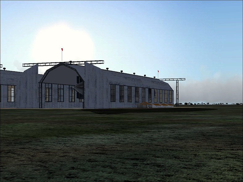 At flightsim: zeppelin_bases.zip Thank you!  |
|
|
|
Post by belov1 on Nov 17, 2009 10:54:06 GMT -5
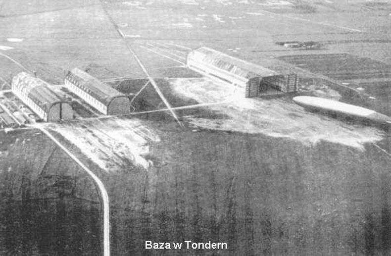
Thanks for comments, Slide! I was lucky to find a good data on both bases, including aerial photos: Wainoden luftshciffhafen: 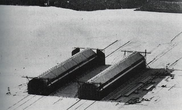 Yambol: 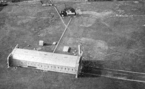 If anybody can give a hand with information, this scenery can be expanded more. Seddin bei Stolp, Hage, Tondern - this are interesting places to build. |
|
|
|
Post by Slide on Nov 17, 2009 12:40:36 GMT -5
|
|
|
|
Post by belov1 on Nov 17, 2009 15:09:27 GMT -5
Excellent!!!! We can do it!!!!  As it was written on the Polish page (sorry, my Polish is not so good): Jezierzyce (German: Seddin) near Slupsk - naval airship base. In 15.VI.1915 the shed Bertha (later - Selim) size 184*35*28 was built. Until 1945 it was used as a warehouse. Constructed by Zeppelin Hallebau GmbH. In 1929-30 this shed was used by Parseval-Naatz GmbH (to built PN.28 and PN.29 airships). In 1916 the second shed Selinde was built (size 241*60*35m) by Gutte-Hoffnungs-Hutte GmbH. It was dismounted in 1921. Also this base had a gas plant and underground storage for 40000 litres of fuel. Following airship were based here: LZ28=L5, LZ58=LZ88/L25, LZ59=L20, LZ62=L30, LZ81=LZ111, LZ83=LZ113, LZ90=LZ120, SL3, SL4, SL6, SL8, SL9, PN28, PN29, PN30 |
|
|
|
Post by Slide on Nov 18, 2009 13:35:42 GMT -5
The Seddin hangar "Selim" existed until 1989. The local fire department had moved in and shortly after ... it went up in flames!!  |
|
|
|
Post by Kofi on Nov 18, 2009 22:48:29 GMT -5
Some nice history here!
|
|
mcpot
Flightsimmer

Posts: 2 
|
Post by mcpot on Nov 24, 2009 18:47:46 GMT -5
dear friends, I'm new here, but I would like to help you. the map of tondern is incorrect in it's direction. I've create a new one with the correct place and direction. note, the google-compass on the right angle of my map, it shows "North" at 5 o'clock. greetz from /andreas www.lutschiff.de  |
|
|
|
Post by Slide on Nov 25, 2009 2:08:56 GMT -5
 Welcome Andreas, it´s nice to see you here. I have often been to your website, which for sure is one of the rare jewels for Airship-Research. Thanks for providing this information, I hope that belov1 reads it in time as he has started work on a Tonder scenery.
|
|
|
|
Post by belov1 on Nov 25, 2009 2:51:20 GMT -5
Thanks, colleagues, for the maps.
May be the exact positions for radiostation and direction finder can be determined too?
|
|
|
|
Post by Slide on Nov 25, 2009 8:23:17 GMT -5
According to the Tondern website the 70m-Directionfinder-Pole was on site. I can´t find any picture of it, but my guess would be opposite to the hangars in the greatest possible distance to the gas plant. That is also a perspective not shown on any of my pictures, so it might hide there?
The Radiostation - 2 other big antennas - was right in the middle of the town of Tonder. I have no other details but "Center of Town".
|
|
|
|
Post by belov1 on Nov 25, 2009 9:55:10 GMT -5
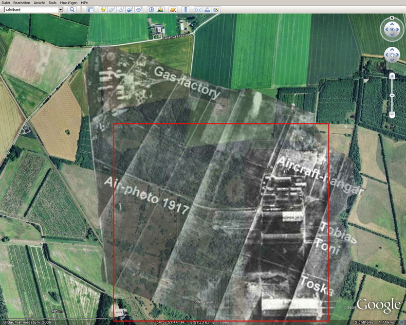
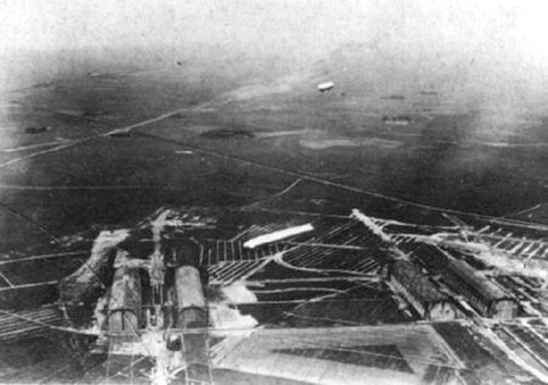
Well, so, aerial view of Tondern base in construction: 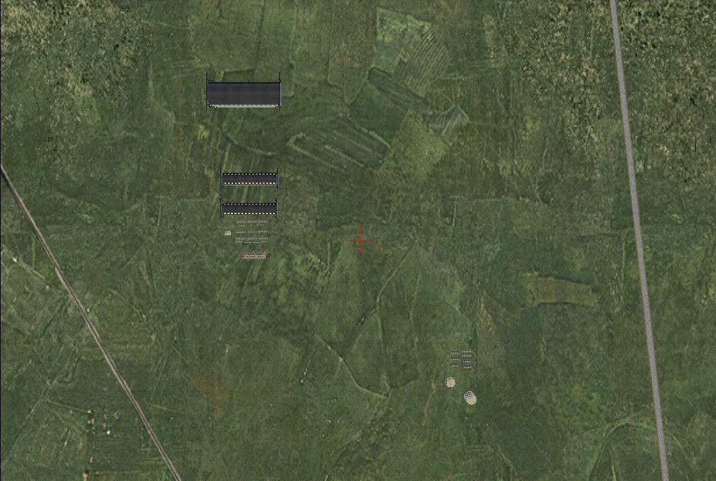 Currently all airship sheds are placed: 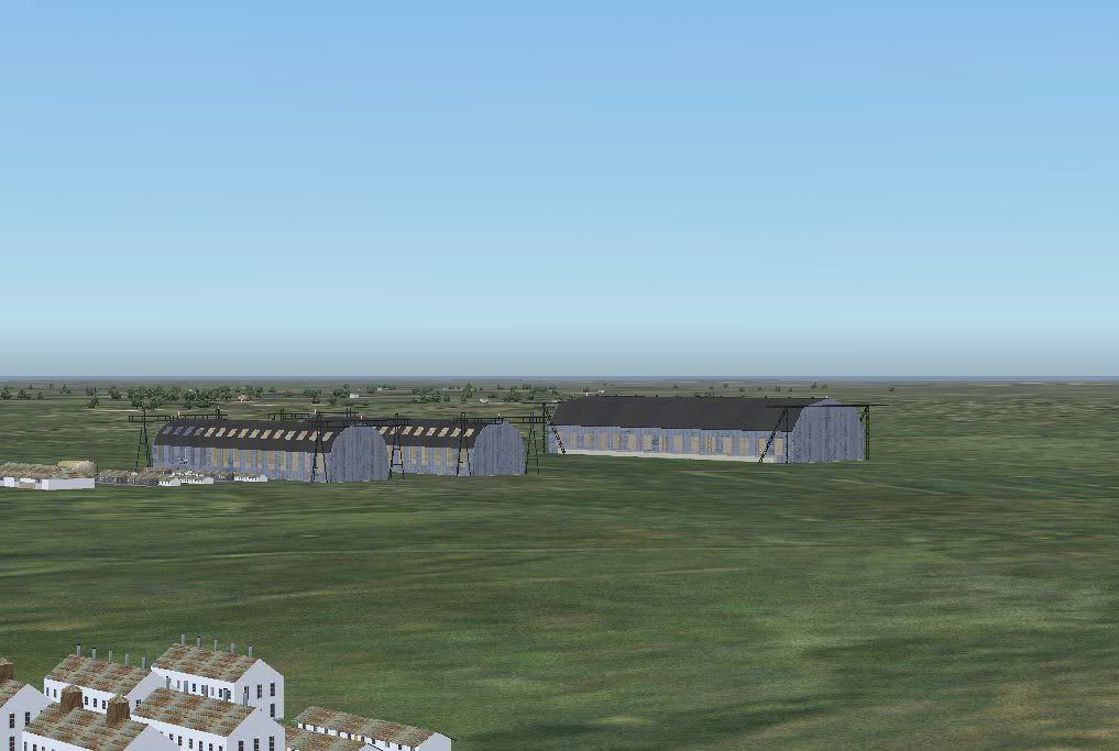 Gas works: 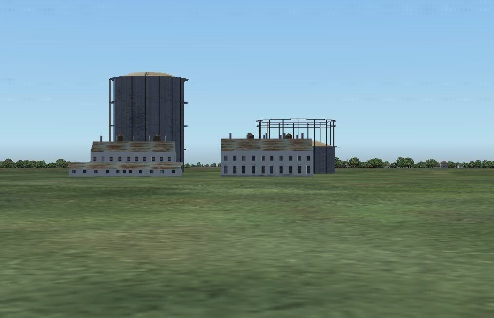 Kite balloon over base to mark the place if mist or low clouds occurs: 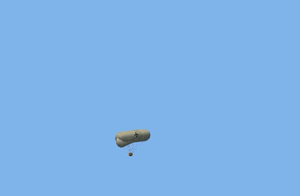 There is a light in the balloon basket during night, but I am not sure if it was installed in reality... I would be very thankful for help. |
|
|
|
Post by Slide on Nov 25, 2009 10:47:17 GMT -5
Excellent!! Did I say I love that balloon? I dropped an email to the tondern admin concerning the antennas, maybe he has answers. And guess what Alexander: I found a used printversion of the "Zeppelins in Combat"-book in german language ("Marineluftschiffe 1912-1918"). Bought it for 15 €, had it in the mail today. Thanks again for your HU, this will be a good read! Edit: 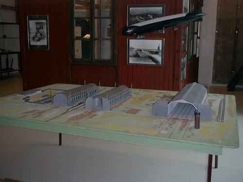 What´s that tower next to the "Toska"? A Watertower? (Picture from the Tonder Museum)
|
|
mcpot
Flightsimmer
Posts: 2
|
Post by mcpot on Nov 25, 2009 11:57:43 GMT -5
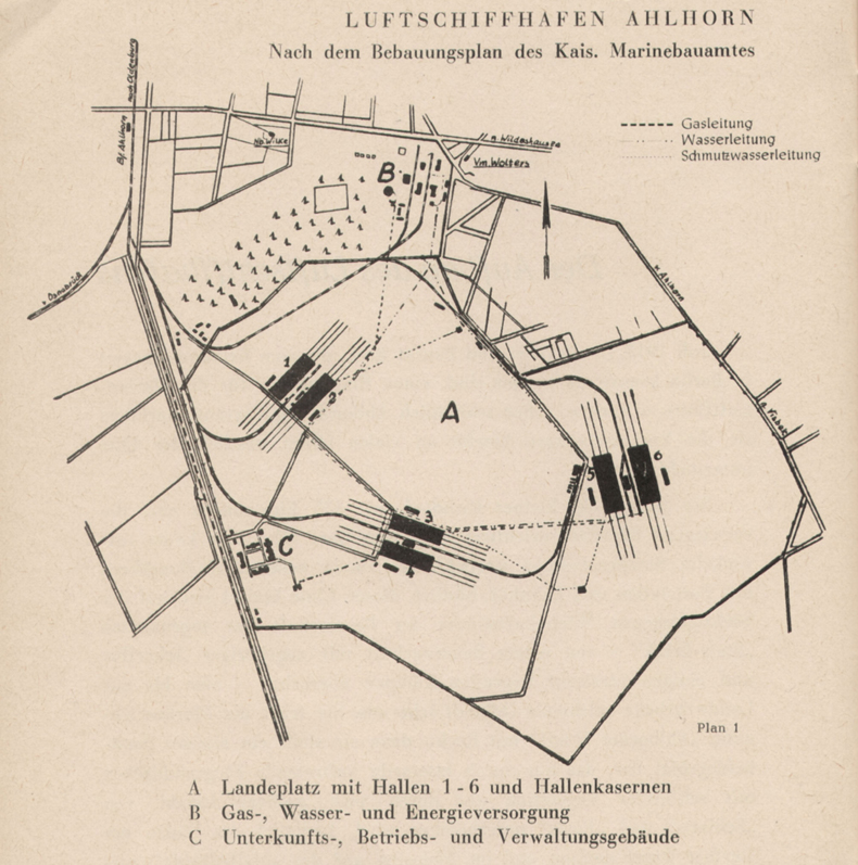
hello friendz, here are now some other maps of tondern: #1: an old map from tondern with the 3 hangar and the railways from the gas-station to the sheds. (preserved in the museum tondern)  #2: todays situation in tondern (with some characteristic points on it)  #3: modell of the hangar in the museum of tondern (the tower in front of toska is only intended as a comparative for the dimension of the hangar)   #4: an old postcard with a view to toni, tobias and the baracks  greetz /andreas www.luftschiff.de |
|
|
|
Post by belov1 on Nov 25, 2009 15:49:43 GMT -5
Andreas, thanks a lot! "70-meters-high mast" was a part of " Telefunken-Kompass" station: www.luftschiffharry.de/faq26.htmIt was installed in Tondern during winter 1917 - 1918. (I need to draw new stop-watch gauge in L-63 radio panel  . ) |
|
|
|
Post by Slide on Nov 25, 2009 16:03:39 GMT -5
I have the correct locations for Radio and Peilfunk: They are N 54 56 48, E 8 52 07 for the radio and N 54 57 13, E 8 52 03 for the Nav. 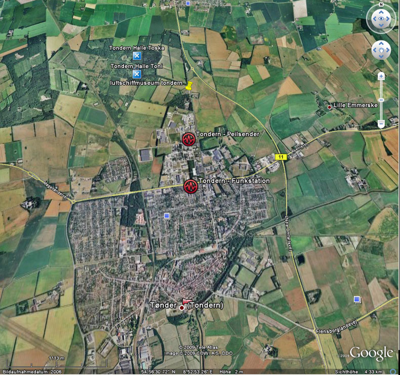 Harry C. Redner ( www.luftschiffharry.de) sent me Googlefiles. Thanks Harry! |
|


 Welcome Andreas, it´s nice to see you here.
  . )
. )